Day 99 ended at the Sahara in Vegas. After a long roll up the Strip in the relentless heat and a stop to take in the popular Vegas sign photo, Garmin decided the Sahara was 13 miles and ¾’s of an hour out into the ‘burbs. Because I was leading, I missed the actual Sahara, then got tangled up in an accident which prevented a U-turn back to the hotel. Thus the mood wasn’t optimised when I finally arrived back there in a pool of sweat. Never mind, this was Vegas, surely nothing could be wrong, and we had 2 whole days to prove it.

First up on Day 100 was bike maintenance. Cindy’s chain was disturbingly ½ tight and ½ loose, so this was being replaced, and my front tire purchased all those months and miles ago in N’orleans at Moto Julia was swapped out. Our experience of the Vegas traffic pushed the theory that nothing could be wrong to the edge, but we made it so decided nothing could be wrong.

Luckily the Sahara was on the monorail line, so the routine was set. Onto the monorail, up the strip, and into the entertainment. Firstly, the Flyover. This is an IMAX-type experience, where you get into a row of seats and are then suspended over a huge screen and virtually fly around the National Parks or Iceland or somewhere. It is very interactive, swooping over the mountains and getting a blast of mist in the face. Then we did the Blue Man Group. The Blue Man Group is difficult to describe, but it involves three men dressed in blue and with blue rubber masks. There is drumming. There is doing things with and to audience members, there is throwing of marshmallows over 10m with incredible accuracy, one of the Blue Men managed to fit about 30 into his mouth. Then of course there was Elvis, we went to the All Shook Up show which was excellent and a lot of fun.

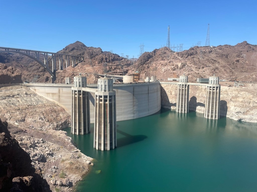
The final sight-seeing was out to Lake Mead, or more specifically the concrete that creates Lake Mead; the Hoover Dam. One of the world’s great engineering projects that gave work to thousands during the Great Depression, it still sits solidly in a canyon holding back the waters of the Colorado River and generating a bit of electricity.
Day 102 was leaving Vegas to never speak of what we’d done there ever again, and heading east to an even bigger, one might say grand, canyon. With Gino on Cindy’s bike to properly run her chain in because she said she didn’t know how to do it, absolutely nothing to do with the air conditioning available in the car obviously, we hit the hot road. Down Highway 93 through Santa Claus, named after a chap who stepped out of his sleigh to drop off some stuff and instantly died of heat exhaustion, and into our first Lower48Mate repeat town, Kingman Arizona. It was 98 days since our last visit, we were US novices back on the 31st May, but were now hardened arteries veterans. This time we got a Route 66 photo, it was too hot last time but the temperatures had plummeted 1°F by now so it was much more pleasant.

Repeating our previous Route 66 up through Peach Springs, we knew where lunch could be found so stopped in for a bologna and cheese and a refuel. Back to the modern highway at Seligman, it was quick to Williams and the left-hand turn that took us due north to the world’s most well-known ditch. We were staying in the Grand Canyon Village, and Cindy and Kim had outdone themselves by booking rooms with views out over the edge.
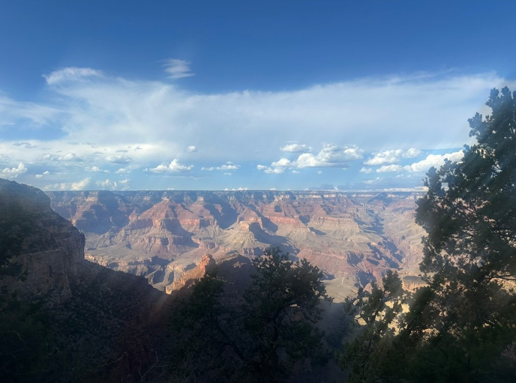
A platter of snacks and a drink while perched on the brink, we admired the sunset, but not the sunrise on Day 103 because that happens too early in the morning. Never mind, there will be another one tomorrow bar some sort of cataclysmic solar event, but we’ll also miss that because it is also too early in the morning. Canyon was the plan for the day. A HOHO style bus cruises west along the south rim, and so we could HO at any of the lookouts then walk to the next lookout and HO again.
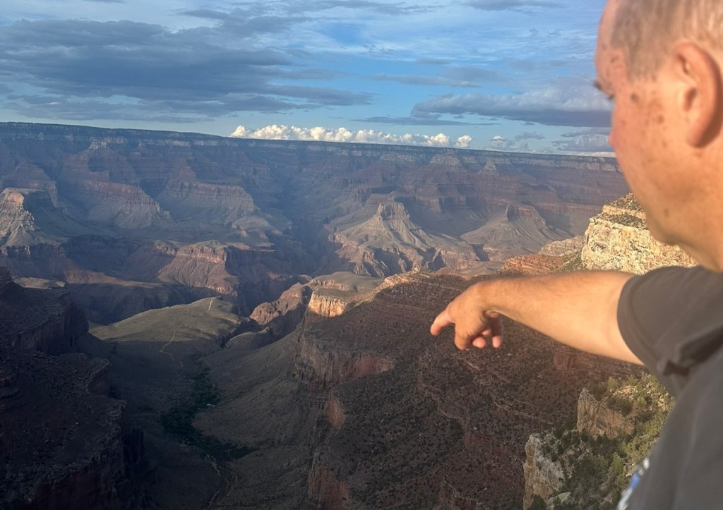
The lookouts give a range of views across the canyon and down into the Colorado River at the bottom. The width of the canyon is created by the water running down the sides, and not by the Colorado itself. The most impressive viewpoint in my whatever-the-opposite-of-humble opinion is the Powell Point, but not much because of the view. The memorial at Powell Point is to Major John Wesley Powell and his teams for two descents of the canyon in rowing boats, the first in 1869 and the second in 1872. The 1869 descent was the stuff of enormous cajónes, imagine setting off in rowing boats down a river that could not be seen in a canyon that in most places could not be climbed out of. Major Powell only had one arm, so the plan B climbing out was beyond his reach.

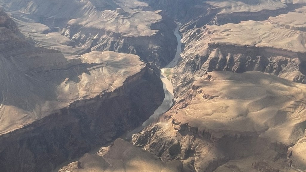
Flashbacks to Iguazu Falls started after a HOHO return to the Grand Canyon Village. We’d done a helicopter flight over Iguazu at eye-watering expense but recognised the enormous benefits of getting a helicopter view of enormous things. So off we went for a helicopter ride, which starts from outside the park at Tusayan. The usual helicopter flight check-in process, including standing on some scales and trying to get a read on the staff girl’s expression as she saw the weight on the display that only she could see. I thought I saw a tiny flicker of “This trip’s going to be on Air Crash Investigation, and this number will be in underlined bold up-front in the executive summary.”, but maybe it was just a “Wow I need to get this baby calibrated, there is no way he could be that.” Hanging around for a bit then started, with wandering outside to look at helicopters before wandering back inside to re-read the history of Papillon Helicopters for the third time. Eventually we were called. There were three of us, Gino had spent a lifetime in the Airforce and if it doesn’t have wings he isn’t interested. Three unlucky punters were added into our group and two had to sit in the middle in the back row, well away from the windows.

Over the forest to the 277 mile long trench, the experience was heightened by Kim opening the window to take a photo while we all wondered how long it would take before the pilot told her to shut it before she lost her phone for God’s sake. About 2 seconds was the answer. Across the canyon, we finally got a clear view of the Colorado River, a major source of water for the southwestern USA. There was no commentary from the pilot which was a little bit weird, we were expecting a bit of “There is Smith’s Gully, named after Jerimiah Smith, who in 1894 dropped his phone out the helicopter window.”
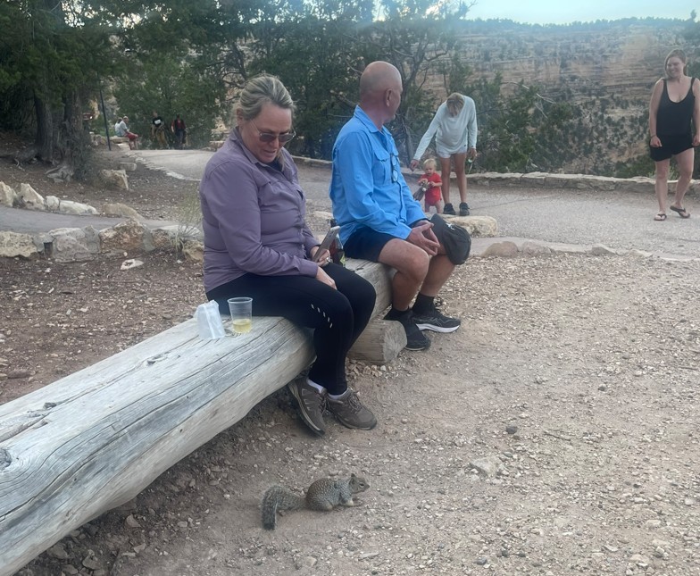
Back to the helipad and back into the village, we called it a day and settled into our little drinks and nibblies spot on the edge of the canyon, this time having to keep an eye out for small children and squirrels who showed too much interest in the white wine for comfort.
Day 104 was time to move on. There is only one direction option and that is east along the south rim before turning north and then west. So basically all directions. First stop was at the Desert View Watchtower at Navajo Point, which looks out to the northeast to the crash sites of two planes, a Super Constellation and a DC-7 which collided in mid-air on June 30, 1956, killing 128 people. The monocular and some trigonometry with a touch of dead reckoning were used to spot the crash sites but given the distance I had to admit we weren’t really sure we were looking at them. Not that anyone was made aware of that, until now. At the time a smidge of “I think I can see a section of the tail on that slope!” was heard.

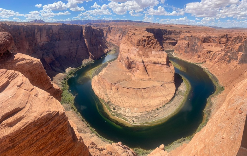
Next stop was Cameron for luncheon. The only place open was Burger King. Trust me. But the highlight apart from purchasing 1.8 times the daily carbs requirement for a sedentary adult was actual adventure riders. These had been surprisingly rare in the US, we’d assumed at the start of the trip the whole lower 48 would be swarming with them. A father-son combo, both on Honda Africa Twins, one from Texas and one from Louisiana, to say we could have talked forever is a gross underestimation for how long we could have talked. Tearing ourselves apart, we headed north while they headed south, with a long way to go. Next stop was a classic bit of scenery – Horseshoe Bend. It is a bend on the Colorado River shaped like a horseshoe; I thought I’d say that just in case you’ve hit your head and lost 98% of your brain function. A slog of a walk in the heat, and we joined the many people taking insane risks perched on the edge of the canyon to get the perfect selfie.
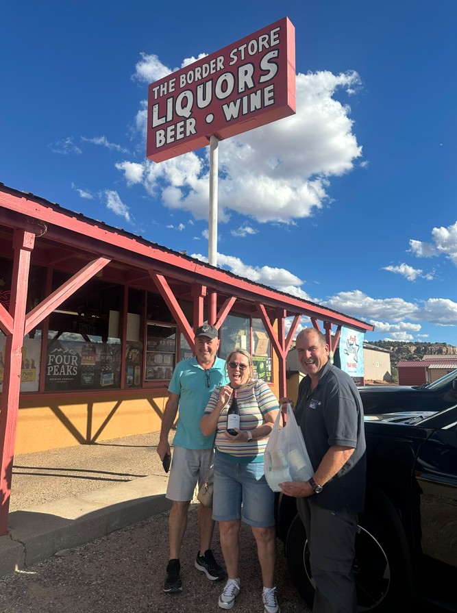
Ploughing on, we crossed the border into Utah and then bounced west along it to Kanab. This town provides a wealth of experience of western movies, National Parks, and off-road insanity. But first we had to BBQ, and to BBQ one needs red. We were in Utah, and yes getting wines in restaurants is fairly easy, but the state-run liquor stores are both hard to find and have minimalist hours. But a quick check of googs maps revealed an interesting fact – Kanab is a mere 5km or 3.4 miles from the border with Arizona. Arizona is very casual with its alcohol dispensing rules. Perhaps there is a place down there that sells red? Turns out there is, and just a thin layer of paint past the border line. Righto.
The BBQ saved, we could relax. But only until Day 105 when we had walking, coffeeing, and side-by-siding to do. Side-by-sides are ubiquitous in the USA, and in places like Utah even more common than ubiquitous. Hiring one is easy. Either one can hire a side-by-side with a guide, or one can drive it oneself. We chose the latter, but with a guide in another one up the front so we didn’t have to spend a long time lost. We first had to do an induction, absolutely no recollection of what the topics or questions were, maybe to keep your seatbelt fastened and don’t wave firearms outside the vehicle, and prove we had a licence. Then off we went a bit north to the Peekaboo Canyon trail carpark, where our guide and our 4 seater side-by-side were waiting. Gino had driven one previously so was nominated as driver No.1, and off we went.

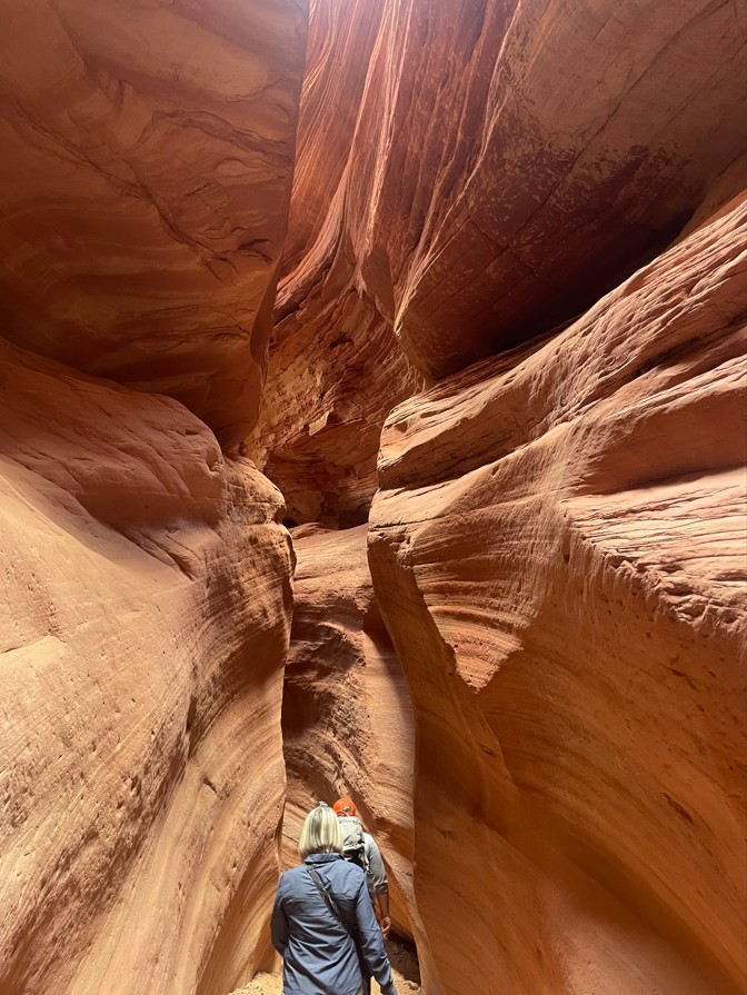
These things will happily roll over anything and will do deep sand and rocks with ease. Being the driver turned out to be a lot more pleasant than being a passenger, to whom it appears as though we were going to tip over in every corner. The driver feels like they are taking a slow trip to the shops, and could go heaps faster. They do tip over though, our guide said that very morning she had warned some people about when they were turning onto a short bitumen bit not to come off the dirt too fast. They came off too fast and rolled it. We were far too experienced to do that with our 30 minutes driving history and got through unscathed. Into Red Slot Canyon, we soon found out why it is called a slot, with a very narrow passage through the sandstone.
A fair time spent looking for and finding fossils, we visited a cave filled with water, then drove at speed back to the carpark. Certainly one of the more fun things we’d done on the trip, and we had dirty red faces to prove we’d done it.

Day 106 was Separation Day. On this day Kim and Gino had to head north to start a cruise from Seattle, while we could kick back in Kanab and do a trip out to the first of our big Utah National Parks, Zion. Zion was only about an hour away, so we decided to take one motorcycle. The road through to the east entrance of the park is quite picturesque, but it was quite hot so stopping wasn’t all that pleasant. We rolled with the slow traffic to the park entrance booth, where rolling stopped entirely. Finally through the snarl, we started to see why Zion is so famous, with awesome rock formations and canyons stretching up into the hills.

The road drops into the canyon via the 1.1 mile Zion – Mt Carmel tunnel, built in 1930. Just for tourists. One look at the surface topography and even the mentally challenged work experience student was heard saying “we need to tunnel this mother”. So they did, and out we popped above a series of switchbacks which descended into the creek. Here we met the problem, with access to the Zion Canyon only allowable by bus. If we were motorcycling in shorts and Bintang singlets and thongs, this may have been a firm yes. But in proper gear we decided to give the bus a miss and went straight to the visitor centre for the mandatory fridge magnet and sticker. Then to lunch in Springdale at a pizza and noodle restaurant where we had neither. With the heat climbing to unpleasant, we called it quits and headed out of the park the way we’d come in.
Back to Kanab, and another sneak over the border for wine, we prepared for Day 107. This was a short day of only 120 miles to Escalante, so we had plenty of time to wander up the Kanab streets and look at new thongs for Cindy. The thong saga had been going on for quite some time and highlights one of the greatest universal challenges of travel, footwear. After years of experience travelling by motorcycle, the absolute minimum I can get away with and carry is three pairs; motorcycle boots, leather walking shoes that in dim light look a little dressy, and the Teva sandals. The motorcycle boots only ever see the inside of a bag when flying at the start and end of a trip or packed into a pannier for overseas transport. The shoes are packed in the luggage. The Teva sandals are strapped to the outside of the luggage. Cindy is a bit the same besides the addition of “Going Out” sandals to support the boots and the Skechers, but her spaghetti strap thongs had shown themselves to be not up to the job. Since North Carolina we’d been hunting for the thong replacement. The USA has Regear shops, these stock second or third or many, many owners ago outdoors gear on consignment, and we found one in Boone North Carolina. The thongs were put on consignment for some other person to discover they weren’t up to it, and a dodgy new pair purchased for about $10. These had revealed many shortcomings, so the hunt continued all across the northern, eastern, and western regions. The hunt was not requited in Kanab, even though an un-named member of the party pointed at a huge number of suitable Teva sandals. Never mind, off to Escalante.
Expectations were enormous heading into the Grand Staircase Escalante zone. I was here in 2015 with a freshly healed fibula, or FHF as it is called in the USA television pharmaceutical ads. I had planned to apply Fibumax, which unfortunately caused suicidal thoughts and tendencies because I couldn’t get the little foil cap off the tube. My doctor or health professional recommended I stop trying. The blue F800GS BMW cured everything on that trip though, one of the best riding days I’ve ever had, even though I didn’t have enough time to go into the National Park.

But this time we were going to do the National Park proper. Up to the sign, we decided to do the drive-by. The history of the drive-by is both deep, and meaningful. Cindy has parked her bike for the photo in front of sacred monuments and precious icons all over the world, and the key is fast in, try not to collide with a child, photo, and fast out. A 5 second drive-by in the Sistine Chapel while the husband grabs a shot is fine. 10 seconds and people start paying attention. 20 seconds and a crowd starts to gather around, some who ride motorcycles and have lost interest in the ceiling, and some who represent the authorities. The latter will start out as calm authorities – you are motorcycle travellers; we respect that you offer no threat. 30 seconds in and the calm authorities will suddenly run the “So you let them ride in, the bloke dropped his bike, it hit that Christ-awful (Christ heard in the background exclaiming Hey!) old candlestick St Peter got from his mother-in-law so he couldn’t chuck it, which flicked up, and busted out God’s hand?” scenario in the big man’s office. Mount up quickly and ride.

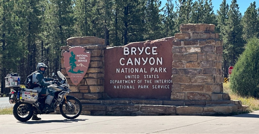
No drive-by in the park, this needed to be absorbed slowly. Firstly, it is not a canyon, there are drop-offs along the edge of the plateau that create the amphitheatres. The challenge is finding the best viewpoints, and we did a bit of riding up and down dead-ends with average views, before accidentally finding a place for lunch. Let’s do some map stuff while awaiting the pizza. Bryce Point seemed a likely spot, why would they name it Bryce Point if it was poor viewing was the logic. The logic was spot-on. Firstly, we lobbed into the motorcycle parking next to a Pommy couple who were on Harleys but loved our Triumphs and we ended up in a long conversation. Then the slog down to the viewpoint. Jackpot.

The feature of the Bryce Canyon is the hoodoos. These are soft sedimentary rock capped by something hard, a bit like the hard chocolate covering over the soft ice-cream on a Choc-Top at the movies. Not a great analogy there because the hard bit disappears first on the Choc-Top, but pretend the patron watching Predator: Badlands was working at the ice-cream without disturbing the chocolate topping and he’s created a hoodoo. The feature of a lot of Utah geology is the colours, the layers of rock cover the rainbow from pinks, reds, yellows, whites (yes I know that’s not a colour, no need for comments thanks), and browns. So the hoodoos are very colourful and a sight to behold.

Bryce done, move on. More amazing scenery, we love it but the early settlers must have absolutely hated it – weathered landscapes where growing anything was impossible, hence the US landscape category of Badlands. Lands that are bad, no ambiguity there. Through the town of Tropic, named by Ebenezer Blowback in 1889. Ebenezer never went to the tropics which is painfully obvious to anyone who has. High desert plateau with humidity of zero and temperatures to match confuse those from the tropics, so we pushed on. Into Escalante, our home for two nights. Dora’s Country Cottage was the target, but the GPS was confused. Fortunately Escalante isn’t downtown Mumbai, it didn’t take too long to find the hotel check-in and the hotel chap on his Harley escorted us up to Dora’s. We had a fantastic house all to ourselves, Dora wasn’t home.
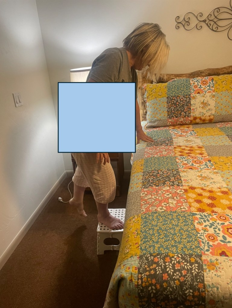
We love these types of places. Down to the supermarket where we schooled the check-out girl who’d always wanted to visit Australia that all she needed to do was add “mate” to her “No worries” and she would blend in, we loaded up with groceries for the home cooked dinner. A feature of the house was the bed. We assumed Dora was a giant, maybe threatening Robert Wadlow’s 8ft 11 inches, because only Robert could easily get into the bed. Luckily an elevated work platform was provided for Cindy. I managed a Fosbury Flop, just clearing the edge of the bed. The Cliffhanger movie came up in conversation and the need for working at heights training were discussed. Someone took a photo but because everyone was in night attire it can’t be shown.
Day 108, a day off. The pressure becomes enormous on a day off. Initial thoughts lying in bed at 6:30 am are sheer happiness – we’ll have a huge sleep-in, a lazy brunch, do a smidgin of laundry, a light lunch with a cheeky rosé, an afternoon nap, read a chapter or two of a non-fiction book to invigorate the evening conversation – Did you know that the Easter Island giant heads Moai were walked into position using ropes!! My ancestors supervising the Stonehenge build should have patented that!! – pre-dinner nibbles, dinner with a bold red, some comedy movie on TV, done. Then at 6:35 am the OMGs start. OMG I’d forgotten all about the motorcycle chain maintenance I’ve neglected for the last 5000 miles. OMG what does my rear tire look like? OMG Cindy’s front brake pads were wafer thin the last time I checked them. OMG I need to sew that button on. OMG I’ve totally forgotten my Business Activity Statement is due, how much do I owe? OMG. OMG. I need to get up right now and try to pull the disaster that is my life together.
Up, realising that none of the OMG’s were worth getting out of bed for because they were all addressed by 6:53 am, the important things could be planned. Hell’s Backbone Road had been a thought for the 10 years since my last ride around the area. Let’s do it. This road was built in the 1930’s so the people could travel from Escalante to Boulder but was replaced by the Million Dollar Highway 12 which actually looks like a worse route to build a road along. As usual any googs research on the current condition of a dirt road is utterly pointless, as the results will range from we tried it in an SUV and we all died from corrugations to I took my Hyundai Getz up there and was so bored I fell asleep. Just do it. It is about 38 miles of dirt, and it climbs to 2,700m so gets nice and cool. Technical challenge? Not really. Just a fantastic road through forests and the rocky Hell’s Backbone ridges.

Hell’s Backbone and the Box Death Hollow Wilderness are examples of the USA need to make geographical features and roads sound terrifying and awesome. Every body part and possession of the Devil and his residential address (666 Damnation Drive, Hell) exist somewhere, including Devil’s Washbowl, Satan’s Sideboard, and Beelzebub’s Boulevard. Death is also celebrated, with Box Death Hollow somehow both terrifying and confusing at the same time. And of course Death Valley, although as the place with the highest ever recorded temperature it probably deserves it.

A highlight on the empty road was a coyote who like me, was not expecting to see anyone so was up very close when it realised I was there. The Hell’s Backbone Road pops out just south of Boulder, so a sneak preview down the Highway 12 and back to Escalante. A fun day.

The plan for Day 109 was the transfer to the famous town just outside the last of the Utah major National Parks, Moab. Up through Boulder to Torrey, the Highway 12 was admired once again. The Civilian Conservation Corps built this (and the Hell’s Backbone Road) and they certainly had their work cut out on this job – mainly rock and more rock. A caffeine top-up in Torrey, and east we went into what looked like worsening weather, straight into a surprise National Park, the Capital Reef. This on is on the main road so we swung into the visitor’s centre for the mandatory fridge magnet and stickers. Yet more amazing rock formations, almost becoming bored with them by now, maybe the Moab parks would perk us back up.

North and east on Highway 24, the weather started to take over as the main focus of our attention. A black cloud was moving in from the west, and the wind was picking up and becoming nasty. If we were in a car we’d have put the foot down, but as we were on motorcycles we twisted the throttle a bit to try to outrun it. We managed to keep in front by a whisker, sincerely regretting stopping to get a photo of the storm front once the lightning started.

Onto the interstate, we could go even harder east so managed to get a handy lead in front of it. Confidence was rising, in fact a bit of hubris crept in and we started making derogatory comments about its abilities. But we had forgotten we had to head south and realised it was about to give us the full broadside. Just out of Moab, it caught sight of us and the race was over. Not for the first time, thinking Boone in North Carolina and Glens Falls in New York, torrential rain hit us, this time with a full ration of hail. Why it always seems to happen just when entering towns and having to slow down and often stop at lights is a question that only the pantheon of rain gods can answer. We are still waiting for their response to our email of the 13th September.

Into the hotel for a couple of nights, all was forgotten and we could move on with Moab. And Moab does not disappoint.


Great read, thanks Duncan.
LikeLike